Lytle Colliery
Primrose was the home of the Lytle Colliery from the 1890's until the early 1950's. The colliery began operations on the Primrose vein from their No. 1 and No. 2 slopes. When the coal company operators discovered how rich the Anthracite coal deposits were at this site, they sunk a shaft that eventually operated on seven levels and reached a depth of over 1,800 feet. At the base of the shaft, the No. 9 and No. 10 slopes extended the mining operations even further. The air, however, was so poor at these depths that compressed air had to be utilized so that the miners could work.
How much coal did the Lytle Coal Company mine all total? Well, let's put it this way. If the coal were loaded on 10-ton trucks placed bumper to bumper, the line would stretch from New York to San Francisco - with enough trucks left over to cover the distance between Primrose and Philadelphia 6 times.
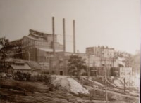
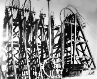
The top photograph shows the colliery's No. 2 breaker, which opened in 1905, and power plant. The bottom one shows the colliery's head frame around the turn of the 20th century. Notice the tank attached to the cable on the upper right wheel of the Lytle tipple. When water flooded the lower levels of the mine, the tank was lowered into the shaft to the level of water. A hatch then opened so that the water could enter the tank. When full, it was hoisted to the top of the shaft and emptied into a portable chute system that carried the water away. When the water level in the mine was extremely high, additional tanks were added to the other compartments. In time, pumps were developed that could extract water from great depths and this system of mine water removal was abandoned.
Maps of the Lytle Colliery
Source: Commonwealth of Pennsylvania, Department of Environmental Protection
Colliery overview
This map shows all major colliery assets including the breaker, shaft, railroads, fan houses, etc. during the heyday of its operation.
Download:
JPG: 6.45 MB
Colliery shaft
This map outlines the Lytle shaft and the intersecting coal veins.
Download:
or
JPG: 6.45 MB
Copyright 2007-2021, Ron Kramer